Cumbria UK Publishes 2nd Attempt at a Final Broadband Coverage Map
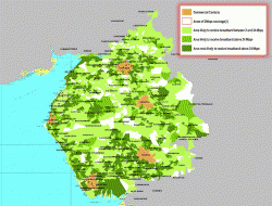
After a lot of media and political pressure the £51m Connecting Cumbria project in England has published a higher resolution copy of their “Final Coverage” map for the local Broadband Delivery UK and BT supported roll-out of superfast fibre broadband services. Now if only there were some roads and other details (postcode data?) or maybe we’re just being picky.
Readers might recall that the original map made headlines after it claimed to be one of the first to be “agreed” by the DCMS and Public Accounts Committee (here); the latter of which has been notoriously critical of the vague coverage maps released by many BDUK projects. But the supposedly final map was of a low quality and the PAC chair, Margaret Hodge MP, later confirmed that the map had not in fact been agreed by her committee as first claimed by Cumbria council.
According to Martin Campbell of the Grasmere Broadband Initiative, the councils new map comes in both a higher resolution format and “also looks like it is scaled correctly on both the x & y axis“. Readers can check out the new PDF formatted map here – http://www.connectingcumbria.org.uk/final-coverage-guide.
Sadly the new illustration, while a welcome improvement, still isn’t the best example of a local coverage map for the BDUK project and the lack of highlighting for roads, villages and towns is notable by its absence. Similarly we still don’t have access to the full street-level postcode data for Cumbria’s deployment, although some Freedom of Information (FoI) requests are being made on that front.
As a side note the wording about Cumbria’s map being “agreed” by the PAC has unsurprisingly been removed and replaced with some general text, which states that their approach is “recommended” by the PAC and DCMS. Make of that what you will. So is this enough?


Mark is a professional technology writer, IT consultant and computer engineer from Dorset (England), he also founded ISPreview in 1999 and enjoys analysing the latest telecoms and broadband developments. Find me on X (Twitter), Mastodon, Facebook and Linkedin.


« UPDATE2 TalkTalk Hike UK Phone Line Rental and Broadband ISP Prices
Latest UK ISP News


- FTTP (5515)
- BT (3514)
- Politics (2537)
- Openreach (2297)
- Business (2262)
- Building Digital UK (2244)
- FTTC (2043)
- Mobile Broadband (1973)
- Statistics (1788)
- 4G (1664)
- Virgin Media (1619)
- Ofcom Regulation (1461)
- Fibre Optic (1395)
- Wireless Internet (1389)
- FTTH (1381)


Comments are closed