Broadband Delivery UK Again Push Councils to Publish More BT Map Data

The latest Public Accounts Committee event, which saw BT’s Group Strategy Director (Sean Williams) receive another grilling by Margaret Hodge MP, has revealed that the Government’s Broadband Delivery UK (BDUK) office is once again writing to councils in the hope to securing a greater publication of viable broadband coverage data.
Readers might recall that last year’s PAC report (here) made a point of highlighting, as a “matter of urgency“, the on-going concerns over the release of vital broadband speed and coverage data for the Government’s state aid fuelled superfast broadband (FTTC/P) roll-out; this is predominantly being conducted alongside BT and aims to cover 95% of the UK population by 2017.
Advertisement
Detailed coverage data for the Broadband Delivery UK project is required because otherwise alternative operators (e.g. smaller ISPs), such as B4RN, can struggle to get their bids for funding from the £20m Rural Community Broadband Fund (RCBF) approved.
The RCBF targets the final 5-10% of premises where BDUK and BT’s project is not expected to reach. But state aid rules prohibit overbuilding, which means that altnets must be able to confirm that their plans will not cross with BT’s. However BT regard this data as “commercially sensitive information” and refuse to release it (here), although in front of MP’s they tend to muddy the waters by shifting the blame on to Local Authorities.
Sean Williams, BT’s Group Strategy Director, told Monday’s PAC event:
“It is a matter for local bodies to decide what information they put into the public domain and some have chosen to put the full information into the public domain and some have put maps in at a slightly higher level. I think the reason for that is because the exact location of the footprint is uncertain at this stage and so there is a risk that people could give them information that could change during planning and deployment.”
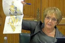
Margaret Hodge responded by saying “I’m not sure that’s honest” before wading into the issue in more depth and waving an example map around, adding that it was “nearly impossible for anybody to identify whether or not their little village or their little area will be covered“. The BDUK scheme last year wrote to Local Authorities requesting that they release more data but, as Hodge points out, this has so far only resulted in most areas releasing generally vague coverage maps (with a few rare exceptions like Dorset).
Meanwhile BT does make a fair point about not being able to 100% identify which areas will or won’t be covered until the BDUK deployment has actually run its course. This is supported by examples like Cornwall (here), where BT’s original aim to cover “at least” 80% of premises was eventually increased to 95% (note: this is not a BDUK project but it’s a good example of how work on the ground can change the deployment plan).
Advertisement
The event also revealed that most or all of the BDUK contracts only required BT to supply 5 digital level postcodes (e.g. BH13 3) instead of the full 7 level (e.g. BH13 3AB), which is one reason why councils might struggle to offer a truly street level detail on their maps. Mind you this also means that even their vague maps are likely to contain some errors due to generalisations of the expected coverage.
The small slice of good news is that BDUK has once again written to all local authorities in the hope of encouraging them to publish the aforementioned postcode data, which would at least be a mild improvement on the current situation. But Local Authorities could just as easily choose to ignore that request and so the debate continues. Credits to Thinkbroadband for spotting the event, which can be watched again HERE from around 16:53 onwards.
Mark is a professional technology writer, IT consultant and computer engineer from Dorset (England), he also founded ISPreview in 1999 and enjoys analysing the latest telecoms and broadband developments. Find me on X (Twitter), Mastodon, Facebook, BlueSky, Threads.net and Linkedin.
« Worcestershire UK Name First BDUK and BT Fibre Broadband Rollout Areas


Comments are closed