Point Topic Publishes New UK Map of Broadband Infrastructure Quality
Telecoms analyst firm Point Topic has today published a new UK map of broadband infrastructure, which uses data collected during June 2012 to measure the quality of each local authority area by the kind of ISPs, networks and technologies that are available.
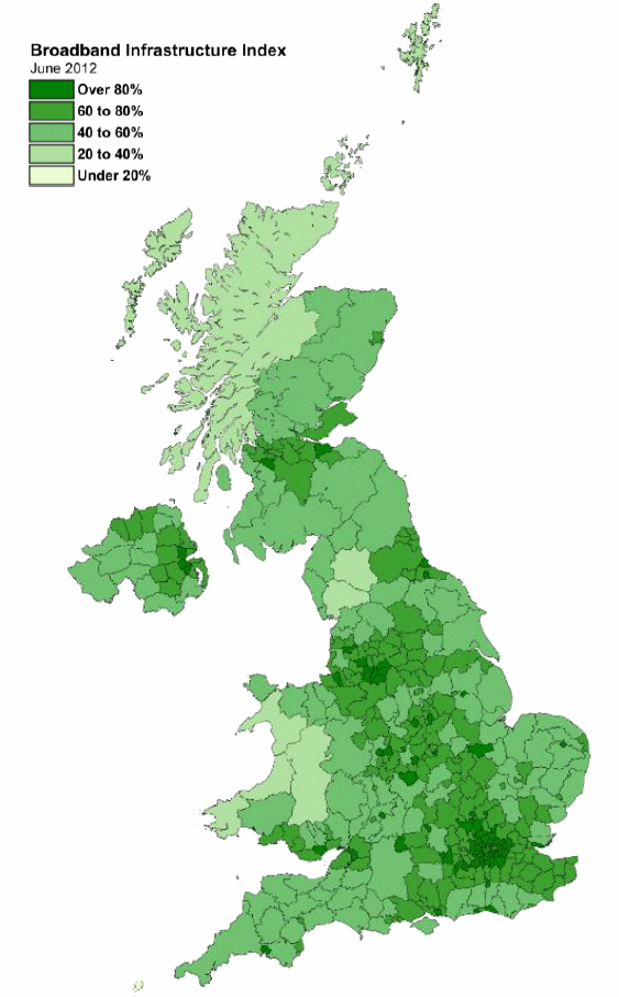
The Broadband Infrastructure Index is an average of six key broadband measures, which includes Local loop unbundling (LLU) availability, BT 21CN coverage, cable (Virgin Media etc.) coverage, access to broadband internet downloads speeds of above 2Mbps and present/future superfast broadband (NGA) service availability.
Advertisement
On the map below areas in a darker green shade have a strong mix of modern networks and those in light green are the exact opposite. As expected the large and geographically isolated rural areas have the poorest selection of services because these are often the most expensive to reach. But Point Topic did find that “overall broadband quality has improved“, not least thanks to BT’s ever expanding deployment of its 21CN network (expected to reach 90% of the country by spring 2013 / 22.5 million premises).
Point Topic also reminded us that the UK will be home to around 26 million broadband lines by the end of 2016 (currently 21m), with 10.8 million expected to come from a new generation of superfast “FTTx” (fibre optic) based connections (this apparently equates to 89% of UK premises with next gen broadband coverage).
Mark is a professional technology writer, IT consultant and computer engineer from Dorset (England), he also founded ISPreview in 1999 and enjoys analysing the latest telecoms and broadband developments. Find me on X (Twitter), Mastodon, Facebook, BlueSky, Threads.net and Linkedin.


« 4G Fixed Superfast Wireless Service Goes Live in Southwark and Reading UK


Comments are closed