FarrPoint Map 4G Mobile Cover on Scotland’s North Coast 500 Road
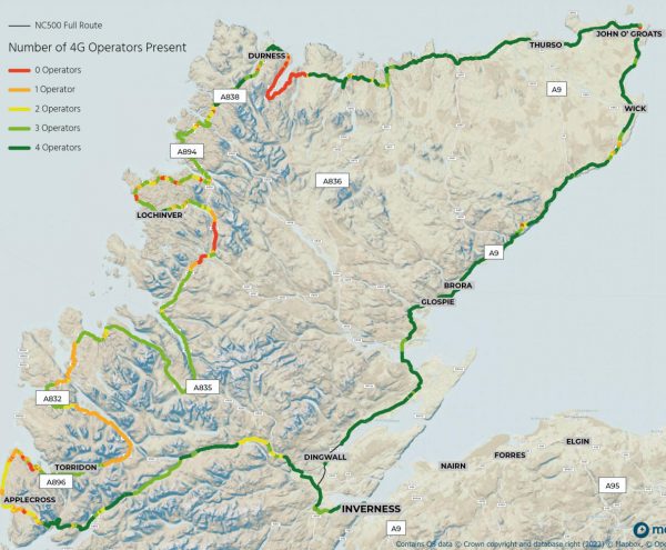
Technical UK consultancy firm FarrPoint has today published an interesting new map of 4G mobile (mobile broadband) network coverage from along Scotland’s most well-known road trip, the North Coast 500. The map is intended to help holidaymakers plan around parts of the 516-mile route where the signal is poor or non-existent.
After surveying the length of the route, which circles northern Scotland, with its Coverage Mapping solution, FarrPoint identified more than 34 miles of road without 4G coverage from any provider. In addition, more than a quarter of the route is only covered by either one or two of the four mobile providers – EE (BT), Three UK, Vodafone and O2 (VMO2).
The digital not-spots extend across some of the most popular tourist hotspots on the road trip – including Inverewe Garden and Estate, the Applecross Peninsula, Beinn Eighe National Nature Reserve and the stunning Clachtoll Beach.
Advertisement
In addition, the road hugging the shoreline of Loch Eriboll – the deepest sea loch in Britain – was found to be the worst area for mobile coverage along the route, with more than 18 miles of continuous road without any 4G coverage. Suffice to say, if you’re using a mapping app for your navigation, then make sure to download it first instead of streaming it.
Andrew Muir, CEO of FarrPoint, said:
“With stunning scenery and views, the North Coast 500 provides the setting for one of the world’s best road journeys right here in Scotland. But without adequate preparation, the trip could turn into difficulty in parts given the remote nature of the surrounding area and the limited connectivity across the route.
With more than 34 miles of the route having no 4G coverage from any operator, and hundreds of miles of road only being covered by certain operators, undoubtedly people will experience connectivity issues during their journey. This may appeal to some travellers who are looking to have a break from their digital devices, but it could equally cause issues if drivers get lost or run into trouble. To help provide better peace of mind, we recommend that drivers check their mobile connectivity and download any maps of areas before they set off to ensure they don’t get lost in this remote, albeit undeniably beautiful part of northern Scotland.”
FarrPoint surveyed the routes with its Mobile Coverage Mapper tool, an autonomous network monitoring device which builds an accurate picture of connectivity by identifying locations that receive limited to no mobile coverage across all major MNOs (mobile network operators). Unlike other solutions, it does not require the expertise of engineers or technicians to man a vehicle with specialist equipment and can be fitted into any vehicle as it drives the route of interest.
Interactive Map of the RC500 Route
https://www.farrpoint.com/nc500-mobile-coverage-map


Mark is a professional technology writer, IT consultant and computer engineer from Dorset (England), he also founded ISPreview in 1999 and enjoys analysing the latest telecoms and broadband developments. Find me on X (Twitter), Mastodon, Facebook, BlueSky, Threads.net and Linkedin.


« Confusion Over GBP5bn Project Gigabit Broadband Rollout in Scotland
Openreach Publish Next 36 UK FTTP Broadband Rollout Areas »


That’s cool! Wonder how long it’ll be before those gaps are plugged; and for how many of the 4G-less areas there’s any other coverage from 2G or 3G.
Certainly a lot better than it used to be, prior to 2014ish Vodafone and O2 didn’t even have 3G on most of these roads.
Wow — Three’s coverage really is appalling. Practically no 4G on the west side.
It’s crazy that in such rural areas there is still no way that the mobile operators can all share coverage to ensure 100% for all customers – particularly in the tourist hot spots that are described. Or maybe there is and Farr Point was doing the study for them? Someone must have paid them for the study!
Crazy indeed and similar to the long standing problems here in West Devon, still loads of single operator masts and zero progress so far with SRN resolving them, the mobile operators seem to have forgotten what the S stands for! We hardly need any completely new cell sites to achieve really good area wide coverage.