New Digital UK Map of Underground Cables Looks to Expand

The Government’s National Underground Asset Register (NUAR), which represents a new digital UK map of underground pipes and cables (broadband, power, water etc.) – intended to help reduce accidental damage, has released a progress update that suggests the map could be expanded and possibly even made accessible to the public.
The Government believes there is huge potential for such location maps from telecoms, energy, water and other providers, which can be used to improve the way that national infrastructure is planned, built and managed (e.g. future full fibre broadband and 5G mobile networks). The map could also cut the amount of accidental damage that occurs to existing infrastructure (one estimate suggested this costs up to £2.4bn each year) and boost economic growth by “at least” £350m per year due to increased efficiency, fewer asset strikes and reduced disruptions.
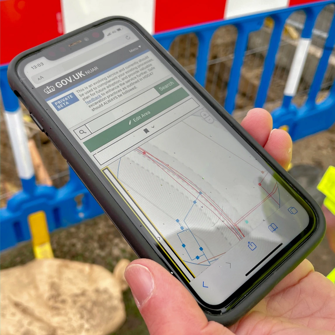
The NUAR – developed alongside Ordnance Survey (OS) and Atkins – is the solution they came up with, which has already launched in its Minimum Viable Product (MVP) form across the North East of England, Wales, East and West Midlands and London. The map is this month also being made available across the rest of England, while Northern Ireland is expected to follow during Spring 2024.
Advertisement
At present the focus of their early launch work is still on delivering the critical safe dig use case for the map. But the latest progress update notes how 75% of respondents to a recent public consultation were supportive of expanding the prescribed use cases for NUAR beyond “safe digging” and increasing access to the data – potentially including giving access to members of the public.
Tentative Proposals to Expand the NUAR
However, with the MVP now available across the whole of England and Wales, and work progressing on updating existing legislation, we believe that now is the right time to explore the potential market opportunities and increased benefits that could be realised through widening secure and controlled access to the vital national asset that stakeholders believe NUAR will become.
Through feedback, and the public consultation, we have identified a number of opportunities where additional value could be delivered. This includes making NUAR data:
➤ available to other user groups for safe digging purposes (e.g. surveyors, land owners and members of the public)
➤ available to support other use cases (e.g. electric vehicle chargepoint rollout, flood risk planning, emergency response, conveyancing, property development, etc.)
➤ accessible via third party intermediaries / APIs, rather than solely via the NUAR user interface
However, these opportunities do not come without constraints and risks, and we envisage that they have the support of among others, the asset owner and national security communities to warrant consideration.
The project team now expects to spend part of the coming year carrying out discovery work, as well as collaborating with individuals and organisations who are interested in such opportunities to test their feasibility and value. “We will also include provision in the updates to existing legislation to make it possible for NUAR data to be securely accessed for purposes other than safe digging,” said the government’s update.
As such it’s too early to tell how much of this will end up being implemented, which we’d image has to be carefully managed due to various issues, such as security and commercial sensitivity. The government will also need to ensure that any expansion not only delivers economic and social benefits, but also has the support of asset owners and other stakeholders.
Advertisement


Mark is a professional technology writer, IT consultant and computer engineer from Dorset (England), he also founded ISPreview in 1999 and enjoys analysing the latest telecoms and broadband developments. Find me on X (Twitter), Mastodon, Facebook, BlueSky, Threads.net and Linkedin.


« Mobile Operator iD Mobile Celebrate 1.5Million UK Subscriptions


Great idea but this map will only be as good as the information that’s fed into it.
Judging by the quality of work of contractors laying fibre optic on behalf of companies such as Cityfibre, do you really think we can rely on them to feed in accurate information?
Never mind the fly by night installers of altnets (and indeed Virgin Media’s network) existing utility data is often pretty poor. Water gas and power companies have been working on digital asset mapping (often referred to as GIS) for thirty years, and there’s still plenty of uncertainty in the records, and digitising the records doesn’t change that, but does often inspire false confidence.
What government hope is that by combining the GIS and mapping of all underground asset owners, they’ll keep an accurate map of what’s where. In reality precision and accuracy will be variable, and updates will be sporadic and sometimes unreliable. Some companies will also be much better than others at creating and updating records, and anything subcontracted to building generalists you’d need to assume the worst.
There needs to be legislation that fines companies who don’t update the system in a timely and accurate manner.
New streets and roads should have ducting where all utilities run through. This can then be accessible and repairs /maintenance can be completed with minimum disruption.
Most new roads and developments will have buried ducts or services, but this is not the problem. The issue is that most ducting or services are owned by different utilities, and sharing that ducting or pipe doesn’t always happen. PIA through Openreach is one example where ducting is shared, but unless I’ve missed something, Virgin Media / NexFibre aren’t subject to similar sharing rules.
In addition to the above, sharing ducts or pipes won’t stop maintenance issues or works from happening. Utilities will still need to dig down or access apparatus and road works will still require time in complex situations. One thing that could help to reduce the impact of such works in new areas would be for services to be located in a service strip or area where works can be undertaken without having to reduce a road down to one lane or close it for safe working. Unfortunately unlike the US, the UK doesn’t have plenty of space to build nice new wide open streets on new developments, so every bit of land is used for development and small streets are continuing to be built that have no room for parking let alone future roadworks to repair ducts located in the middle of the road.
@Richard. It’s not always that simple as some utilities, such as gas and electric, you generally don’t want to mix and for safety need to be done at separate depths.
Now, there is some merit in putting all telecoms cables down a shared duct, which does actually happen in some areas via co-operative agreements. But the reality is that, to be effective, this would have needed to be done a long time ago. Sharing of existing ducts is much more tedious due to reasons of competition and regulation (Openreach are required to do it by Ofcom, but that’s only because they have significant market power) and, even when allowed, it isn’t always viable in every location.
Today’s digital infrastructure market is very competitive and there’s an element of herding cats whenever you try to get rivals to work together co-operatively, without breaching rules. There are some reports floating around that delve into the challenges of this, although off-hand I can’t recall the links.
“New streets and roads should have ducting where all utilities run through. This can then be accessible and repairs /maintenance can be completed with minimum disruption.”
I’ve managed big capex programmes for the water sector, and worked for electricity companies, and that’s a neat idea, but would be very troublesome and expensive to make work. In theory concrete lined trench under a pavement would work perfectly, but to contain multiple utilities common ducting would need man-access almost continuously or every few yards, mixes things you don’t want mixed – eg sewers and drinking water pipes in the same void, water pipes near electricity, electricity near gas. An underground chamber becomes a confined space that has specialised working requirements, and if you get a gas leak (or even methane from sewer leaks) there’s an explosion risk. Some utilities are also pretty large, so if you want one size fits all, it becomes a big common duct with a cross section over a metre. The failure mode of gas, water and electricity is also different in ducting – so a failed electricity cable is usually a mini explosion, but when it happens in directly buried it causes no harm – in a common duct that would take out gas and water as well, either by the blast effect or flames melting the polyethylene pipes. A gas leak we’ve already touched on, water is pretty obvious. A sewer leak would be a real issue because the entire duct sections would need cleaning out. As an underground space it’s also vulnerable to surface water flooding, and would create a rat superhighway, and the individual property connections would be more expensive if you route them to avoid a “spiders web” across the duct.
Whilst it’s a pain the dig up, install new, or fix faults, there’s very good reasons why most infrastructure is directly buried.
If its anything like Gigamap it will, on occasion, be inaccurate. There is also a security aspect to consider. Cabs are definitely more secure than they used to be, but I can see this kind of data being used for nefarious purposes….I’d like to see it opened up for genuine installers / construction / developers though.
The big flaw in the English plan from a telecoms perspective is that BT’s infrastructure is not on it. As far as I can determine Openreach are “looking at this”.