Opensignal map shows where UK Mobiles connect to Starlink’s D2D satellites
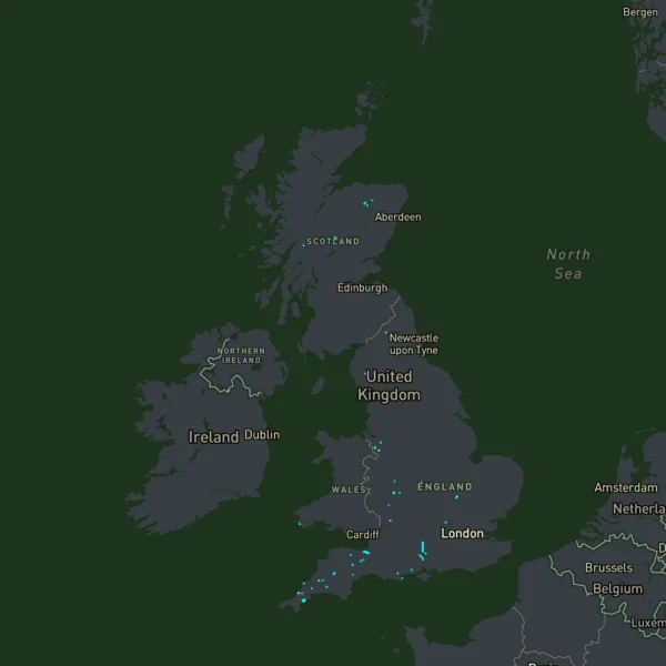
Market analyst and network benchmarking firm Opensignal, which examines mobile networks by gathering crowdsourced data from users of their App, has published what they’re calling the “world’s first interactive map of satellite-to-smartphone D2D connections” (Direct-to-Device) – currently showing where people are connecting via Starlink’s satellite mobile network.
At present O2 is the only UK mobile operator selling a consumer Direct-to-Device (D2D) based O2 Satellite service (here), which enables normal Smartphones to connect to their UK 4G mobile network via Starlink’s cell-focused broadband satellites. Regular readers may recall that the consumer variant of this service typically costs an extra £3 extra per month and harnesses a small 5MHz (paired spectrum) part of the 1800MHz (B3) band.
The Opensignal D2D Satellite Map thus currently only shows D2D connections via Starlink’s network, although this will be expanded to cover additional D2D networks as new satellite operators (e.g. Amazon’s LEO) begin to make them commercially available around the world in the near future.
Advertisement
The map itself lets users zoom from a global view down to individual locations to see exactly where D2D activity is occurring. Every point represents a location where smartphones have connected to a D2D service since January 2026, drawn from Opensignal’s billions of real-world measurements. The map will be updated monthly.
As can be seen from the screenshot on this article, a lot of the UK’s D2D connections via O2 Satellite are occurring in rural areas (as expected), as well as seemingly along some roads that may have patchy mobile coverage from O2’s terrestrial 4G and 5G network infrastructure. Interestingly this seems to include a big stretch of the A34 in the South of England. One catch here though is that we don’t know how many samples are being taken before a dot on the map is rendered.
Mike Sandy, President, Market Performance at Opensignal, said:
“D2D is reshaping who can deliver mobile coverage, and where, because the phone in your pocket can now reach a satellite directly. Until now, the industry has had to make decisions without knowing where momentum and adoption are real.
The Opensignal D2D Satellite Map provides an independent view of where D2D is taking hold across the globe, so decisions about partnerships, spectrum and devices can be grounded in how consumers are actually connecting today. As D2D matures, that view will only become more important.”
At present Starlink has an overall total of c.11,130 satellites in orbit for both broadband and mobile services – mostly at altitudes of between c.340-550km, although only around 650 of those currently supply their DtD/DtC mobile platform, which offers a fairly basic (c.5Mbps) and app-specific 4G remote roaming style service.



Mark is a professional technology writer, IT consultant and computer engineer from Dorset (England), he also founded ISPreview in 1999 and enjoys analysing the latest telecoms and broadband developments. Find me on X (Twitter), Mastodon, Facebook, BlueSky, Threads.net and Linkedin.












« Gigaclear UK completes North Oxfordshire Project Gigabit broadband contract
Advertisement
Leave a Reply
Privacy Notice: Please note that news comments are anonymous, which means that we do NOT require you to enter any real personal details to post a message and display names can be almost anything you like (provided they do not contain offensive language or impersonate a real person's legal name). By clicking to submit a post you agree to storing your entries for comment content, display name, IP and email in our database, for as long as the post remains live.
Only the submitted name and comment will be displayed in public, while the rest will be kept private (we will never share this outside of ISPreview, regardless of whether the data is real or fake). This comment system uses submitted IP, email and website address data to spot abuse and spammers. All data is transferred via an encrypted (https secure) session.
















For many years I’ve been saying that the South West, especially Devon is the worst served area in the UK for mobile coverage, well here you have the proof..
Worst served *by O2* at any rate. Or maybe just more popular away-from-home destinations.
A421 – A1 junction on Cambs/Bedford border is a white spot for at least 10 years now. O2 is a joke network.
It’s interesting there are no connections at sea. We have ferries back and forth to Ireland and Holland where there would be no service.