North Lincolnshire UK Shows How to do a Proper BDUK Broadband Map
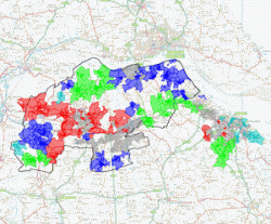
The North Lincolnshire Council in England deserves some credit after they published a fairly detailed and interactive postcode map of the local Northernlincs Broadband (NLBB) project, which is working with BT to ensure that “92.5% of premises in each area will have access to superfast broadband” (FTTC) by spring 2015.
As usual the new map only represents tentative data, which is subject to change as BTOpenreach’s engineers survey the areas prior to each phase of the deployment, but it’s still a significant improvement over the woefully vague attempts of some other county councils. The fact that you can also search by postcode and zoom right in is a notable bonus.
Advertisement
The project is also following the example of some other local Broadband Delivery UK (BDUK) based schemes by publishing a list of street cabinet upgrades, although Phase 1 (April – September 2014) of their deployment was only announced last month (here) and thus at present the only entry on the page is Cabinet 26 at Swift Drive (Scawby Brook).
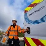
BT’s local deployment will predominantly focus upon rolling out their up to 80Mbps capable Fibre-to-the-Cabinet (FTTC) technology and 31,000 premises are expected to benefit. Hopefully more local authorities will decide to follow suit and also make the relevant postcode data available to smaller ISPs, such as those seeking public funding through the RCBF; but not everybody seems to be doing so. Credits to Thinkbroadband for spotting this.


Mark is a professional technology writer, IT consultant and computer engineer from Dorset (England), he also founded ISPreview in 1999 and enjoys analysing the latest telecoms and broadband developments. Find me on X (Twitter), Mastodon, Facebook, BlueSky, Threads.net and Linkedin.


« EU and UK Next Gen Broadband Uptake Improves But 100Mbps Still Rare


Comments are closed