First Ever Independent 4G Coverage Map of Newcastle and North Tyneside
Technical UK consultancy firm FarrPoint has just created something rather special – the “first ever” independent 4G mobile (broadband) coverage map of Newcastle and South Tyneside. The study was designed to “comprehensively” map out the region’s mobile phone “not spots” in order to help the local authority to improve connectivity.
If there’s one thing that most people can probably agree on, it’s that the maps of mobile network coverage produced by EE (BT), Vodafone, O2 (VMO2) and Three UK are not always the most accurate or useful. In fairness, mobile signals can easily be impact by all sorts of changes in the surrounding environment (weather, new buildings, tree growth etc.), so it’s not an easy thing to get right.
Similarly, attempting to produce an independent map of such signals is arguably even harder, since you’d need to go out and physically record how the signals change as you move around – that’s a lot of work. Nevertheless, this is precisely what FarrPoint set out to do after Newcastle City Council (NCC) identified that this was one of the big concerns among local people (they did this by analysing social media comments).
Advertisement
Cllr Joyce McCarty said:
“While we’ve made significant progress in increasing the availability of fixed broadband infrastructure, the levels of mobile coverage has been less clear due to the way it’s reported by mobile network operators, meaning it’s been almost impossible to identify any partial or total ‘not spots.’
This piece of work rectifies that, accurately reflecting the on-the-ground experience that residents and businesses are likely to receive. It clearly shows that mobile coverage is not currently maintaining pace with developments, with areas of newer homes less likely to enjoy good signal than our more established communities.
Having this fresh understanding will now allow us to engage with the networks in order to collaboratively try and improve coverage for everyone.”
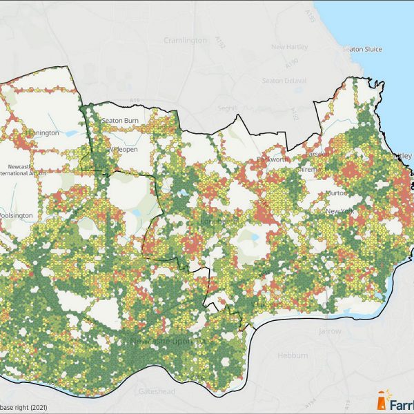
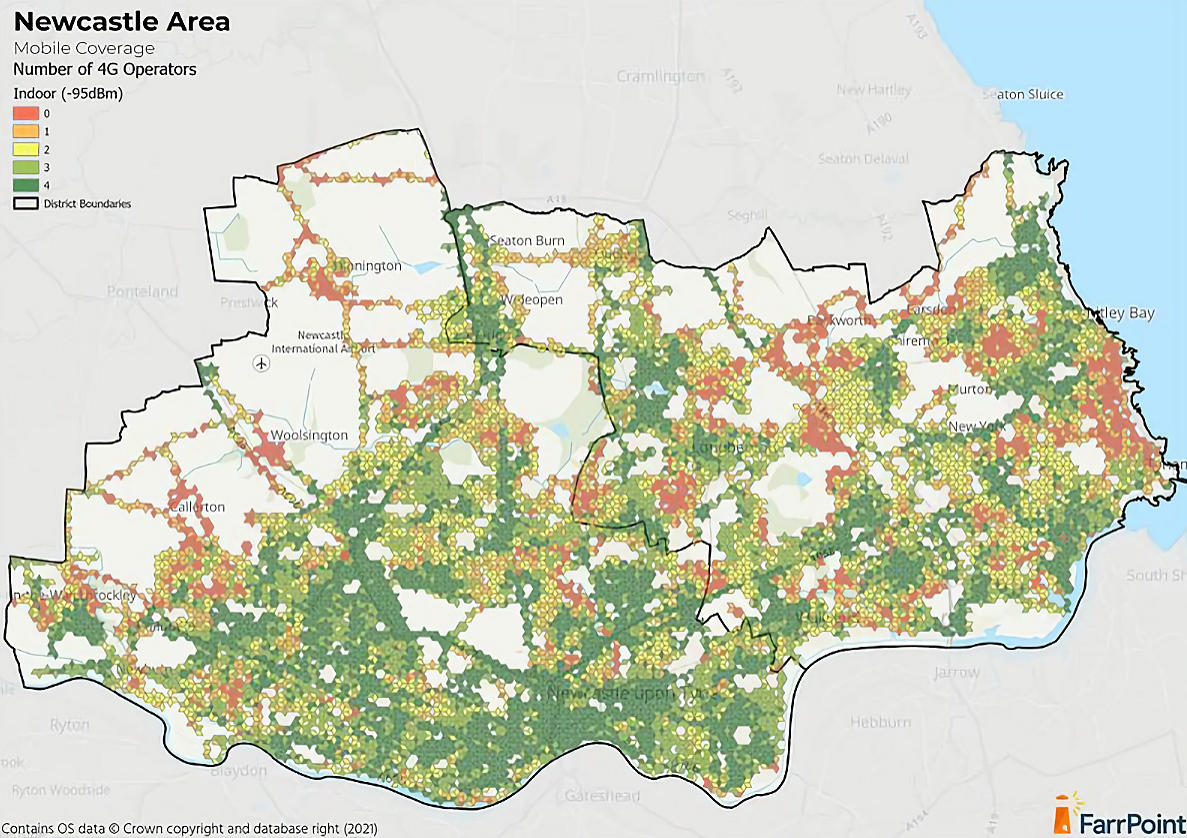
Using a vehicle mounted unit, FarrPoint drove more than 1,800 miles, measuring real-world 4G signal strength for the main four operators over a 2-month period and collecting almost 130,000 data points. The results of this survey were used to “accurately” map outdoor and indoor 4G coverage (using a minimum threshold of -105 decibel milliwatts (dBm) for outdoor service and -95dBm for indoor service – Ofcom’s measure).
The majority of the survey area was found to have outdoor coverage from all four networks, yet in some areas, such as Woolsington, or where recent developments have taken place to the west and north of Newcastle, signal was more limited. Indoor coverage followed a similar pattern, however up to 10% of the city was potentially found to have no adequate 4G signal, including parts of areas like Dinnington, North Gosforth, Chapel Park, Lemington, Throckley, and West Jesmond.
Indoor 4G mobile coverage map
Advertisement
FarrPoint say they have also successfully completed a similar mobile coverage map for West Sussex County Council. The big downside for consumers is that there’s no easy way for ordinary folk, that we’re aware of, to access this data and interact with it, which is a shame. But hopefully NCC will be able to make some constructive use of it.
Meanwhile, doing this across the whole of the UK would probably be far too slow and expensive, with the data quickly becoming out-of-date – as networks are constantly being changed / upgraded. Credits to James for spotting the news.


Mark is a professional technology writer, IT consultant and computer engineer from Dorset (England), he also founded ISPreview in 1999 and enjoys analysing the latest telecoms and broadband developments. Find me on X (Twitter), Mastodon, Facebook, BlueSky, Threads.net and Linkedin.


« Quickline Build 900Mb Broadband to Lissington in Lincolnshire UK


Does anyone have the map in High resolution?
https://www.farrpoint.com/uploads/store/mediaupload/392/image/NCC01_X1V5_Mobile_Survey_Outdoor.jpg
FYI – That’s the outdoor coverage map.
What a good idea. I’ve always complained about the official coverage maps which bare no resemblance to reality where I live. (They tried to fit a smart meter a few years ago – I told them there was no mobile signal and they just didn’t believe me. They soon gave up when they tested the actual signal.). There should be more of these maps made to accurately show the not spots.
Can someone explain to me how a car travelling on the road is able to generate accurate data for indoor areas?
Theoretical -10dBm difference. So better than provider maps as it should represent what is out in your road. Actual indoor difference will depend on the fabric of your house.
Indoor shouldn’t now be an issue as most people can use WIFI data offload and WIFI Calling.
“ Indoor shouldn’t now be an issue as most people can use WIFI data offload and WIFI Calling.”
Which is great, until your internet goes down. Either because of a connection problem (cable fault, isp fault) or something like a powercut.
And seeing as some providers have mobile data as the backup, Vodafone and I believe BT have such “offers” off such service, then if the mobile data where you are is bad or useless, then having that as a backup for when the proper connection fails, really fails the end user who would be relying on (and expecting it) to work.
Wifi is also no good when you are in a town centre going in and out of shops. Sure some might have wifi, some might be freely open that you can just roam from store to store, but having to register for each stores own wifi? Non-starter.
So, in my opinion, what should happen, is mobile operators should provide this level pod detail as their coverage maps, not computer generated guesses. And it should be on them to ensure their mapping, to this detail or better, is kept up to date, constantly, almost in real-time (to reflect changes – upgrades – to their network to keep it accurate)
SM, I agree the theoretical coverage published by providers is near on useless and does not represent the actual experience. However it’s not just the signal coverage but the network settings and thresholds imposed by the providers that determine what your device can use.
If you are using Mobile Broadband as a backup then if you are in a really good reception area the backup device can be in your lounge, if weaker signal then it has to be in the loft, outdoor only requires an outdoor aerial or device and if no 4G signal use an alternative.
Our inability to be able to walk into any shopping centre, office complex or public space etc to pick up WIFI for our mobile devices is that we have failed to pursue cross WIFI agreements and a universal login. When WIFI first arrived we had agreements between providers (BT, The Cloud etc) to connect via each others APs and lots of people since have decried the FON concept. As always there was no money in it. Going forward it will probably now fall to small 5G antenna for indoor use but that will continue to be provider specific.
The closest we have to universal WIFI is BT WIFI but this is provider specific, bandwidth strangled, scorned and turned off by many. Using WIFI from our mobiles is in the interest of the mobile providers hence why they now promote it as it keeps their network costs down. A universal WIFI login would be a lot cheaper than getting provider specific indoor 4G/5G coverage to every premise.
http://www.opensignal.com offers apps that anyone can install and provide crowd sourced signal information from real world situations. This is used to produce coverage maps similar to that shown, without the need to drive all those miles.
Yes if we could have one app with the level of granularity required.
Opensignal like Rootmetrics do not provide their source data (as they naturally make money from the information gathered), nor the basis of their modelling, do not have comprehensive coverage, not dynamic enough and simply does not go to the level required. Most of these apps are only used by those interested and don’t mind their battery being depleted. Hence why companies like Farrpoint are engaged to provide coverage in a specific geographical location in a set period.
If you use Opensignal you get “Network Stats is unavailable at this zoom level, please zoom out” which isn’t very helpful. The Rootmetrics hexagons are better but their descriptions are so generic you can only make general assumptions like which provider.
Yes if we had a universal app, without all the bloat that recorded provider, cell, frequency, LTE/NSA/SA, EARFON, RSRP etc etc great but it would need to be searchable at that level including when captured. But with the ongoing inconsistency and unpredictability of both existing and new existing mobile provision this is likely to remain unachievable for some time.
Until then we are left to continue testing the actual service for each provider with a selection of PAYG SIMs.
CellMapper.net is a lot more useful with a website that actually shows you individual data points on a map as opposed to trying to get one to license stuff.