Streetwave UK Find Big Gap in Mobile Broadband Coverage Across Moray

Network analyst firm Streetwave have today shared the results from a recent survey they conducted, which tested the mobile broadband coverage and performance of 4G and 5G networks – including EE, Three UK, Vodafone and O2 – across the Moray Council area in Scotland. Overall the study found a 40 point performance gap between the best and worst mobile networks.
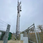
Streetwave typically works by harnessing waste (bin / refuse) collection trucks to map mobile network coverage and speeds across various parts of the UK (e.g. here, here, here, here and here). In this setup, refuse trucks are installed with several off-the-shelf Smartphones using special software, which run continuous network tests (once every 20 metres in rural areas and 5m in urban areas) as the vehicles go around their routes.
The data they collect is often then used by local authorities to help identify areas that may require additional intervention in order to improve local mobile coverage and or network capacity, while also giving locals access to some of this data via address-based coverage checkers and interactive maps (https://app.streetwave.co/coverage-checker/moray).
Advertisement
The latest study in Moray (based on data collected between May 2025 and March 2026), which was carried out in partnership with Moray Council, found that EE had the highest “Essential Coverage” across the Moray Council area at 84%. On the flip side, Three UK had the lowest Essential Coverage at 44%, meaning more than half the area receives no reliable signal from the network.
Streetwave defines Essential Coverage as being reflective of locations where the mobile network provides users with data speeds of above 1Mbps download, 0.5Mbps upload, and below 100ms (milliseconds) of latency (i.e. covering or allowing only the most basic of use cases / needs).
Essential Coverage Scores
Sadly those are all the results we get.


Mark is a professional technology writer, IT consultant and computer engineer from Dorset (England), he also founded ISPreview in 1999 and enjoys analysing the latest telecoms and broadband developments. Find me on X (Twitter), Mastodon, Facebook, BlueSky, Threads.net and Linkedin.


« WightFibre Join UK Government Charter to Stop Unexpected Bill Increases
Advertisement
Leave a Reply
Privacy Notice: Please note that news comments are anonymous, which means that we do NOT require you to enter any real personal details to post a message and display names can be almost anything you like (provided they do not contain offensive language or impersonate a real person's legal name). By clicking to submit a post you agree to storing your entries for comment content, display name, IP and email in our database, for as long as the post remains live.
Only the submitted name and comment will be displayed in public, while the rest will be kept private (we will never share this outside of ISPreview, regardless of whether the data is real or fake). This comment system uses submitted IP, email and website address data to spot abuse and spammers. All data is transferred via an encrypted (https secure) session.


It would be helpful if the coverage viewer would allow selection by connection type: 4G, 5GNSA, 5GSA (and remnants of 2G).
Yes I know you can get a calculated view of that information on operator coverage maps to some level of detail (and also spot the “coming soon” of the Voda Three integration) but streetwave display is an easier to consume overview for a wider areas and an a more real world view rather than calculated
The one thing that is missing (or at least I cannot find reference to such) is the antenna/handset height above ground. Unless they can quote that the results are, IMHO, worthless. When I was involved professionally in mobile comms our published results always defined the antenna height (1.5m above ground on vehicles, 1.4m above ground handheld).
The results in this article could be obtained from handsets inside the vehicle or antennas mounted on the vehicle roof. Antennas on the vehicle roof will be much higher so have better performance.
The inland half of that council area has very low population density, so I am not surprised at the low coverage levels.
The more populated areas tend to be small towns and rural, so coverage levels are I suspect much like similar areas in Scotland.
Mark your photo has a Highland council waste collection truck instead of a Moray Council waste collection truck!
That’s because Moray was one of several regions included in the original survey announcement, and they only included the Highlands truck in the PR media.