Streetwave Make Maps of UK Mobile Coverage and Performance Available

Network analyst firm Streetwave, which is currently conducting various UK surveys to study the coverage and speed of 4G and 5G mobile (broadband) networks across the UK using bin lorries and private vehicles, appears to have responded to some of ISPreview’s suggestions by making interactive visual maps of their findings available for free to the public.
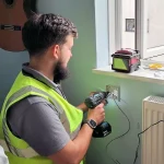
Over the past year Streetwave have been harnessing waste (bin / refuse) collection lorries to map mobile network / broadband coverage and speeds in various parts of the UK, particularly Wales (here, here, here, here and here). In this setup, refuse trucks are installed with several off-the-shelf Smartphones using software from Streetwave on top, which run continuous network tests (once every 20 metres in rural areas and 5m in urban areas) as the vehicles go around their routes.
The data is being used by local authorities to help identify areas that may require additional intervention in order to improve local mobile coverage and or network capacity. In addition, members of the public have also been given access to some of this data via an address-based coverage checker (more will become available as the studies are completed), but until now this was quite limited.
Advertisement
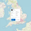
The good news is that Streetwave have now started to add interactive maps to their coverage checker, which enables people to see a visual overview of each study region and thus how each mobile operator performs over a much wider area – without needing to enter lots of individual addresses. Admittedly, this is fairly basic, but it’s still a big usability improvement.
At launch there are only a few maps available, but we expect this to grow in quantity and sophistication over time. The data will surely make for an interesting contrast against the somewhat rough estimates of coverage and performance produced by the mobile operators themselves.
Which Streetwave Maps Are Publicly Available?
Torfaen County Borough Council:
https://app.streetwave.co/coverage-checker/58/mapNorfolk County Council:
https://app.streetwave.co/coverage-checker/55/mapCaerphilly County Borough Council:
https://app.streetwave.co/coverage-checker/48/mapTyfu Canolbarth Cymru | Growing Mid Wales:
https://app.streetwave.co/coverage-checker/56/mapRiver Severn Partnership Advanced Wireless Innovation Region:
https://app.streetwave.co/coverage-checker/60/map


Mark is a professional technology writer, IT consultant and computer engineer from Dorset (England), he also founded ISPreview in 1999 and enjoys analysing the latest telecoms and broadband developments. Find me on X (Twitter), Mastodon, Facebook, BlueSky, Threads.net and Linkedin.


« Major Yayzi Network Migration Triggers Super Slow UK Broadband UPDATE2


Now, we just need it on a widescale basis, which, with time, is more than possible.
Fascinating to compare the overall coverage between operators. Obviously there are local variations but fundamentally EE seems to do much better than the other operators.
Except indoors where they are terrible.
Excellent maps, pity no App??? Navigating the maps on an iPhone is quite difficult.